Development of geographic information system database
Summary
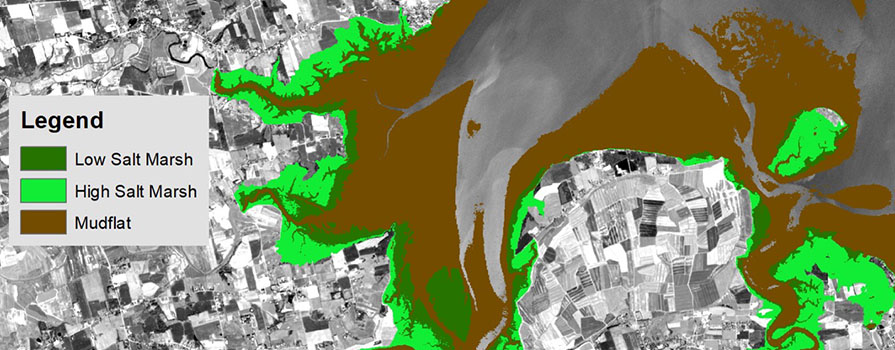
NSCC Applied Geomatics Research Group (AGRG) and the Canadian Wildlife Service have partnered to construct a geographic information system (GIS) database of features in the Inner Bay of Fundy (IBoF). This high-resolution data helps inform efforts to conserve and potentially restore important wildlife habitats. The Bay of Fundy is famous for having the highest tides in the world with a maximum range reaching 15 meters. As a result, mudflats and salt marshes are significant features of the landscape and the rivers that drain into the bay are highly influenced by the tide. AGRG researchers mapped the head of tide for major rivers and the extent of saltmarshes pre and post dyke construction by the Acadians. The GIS database provides the IBoF planning team with foundational baseline information to inform them on design, delineation, conservation strategies within the bay and methods to monitor effectiveness over time.
Challenge
The IBoF Working Group required extensive data to support decisions surrounding coastal and marine conservation within a defined scope area. Reliable information on some key ecological areas, such as the extent of saltmarshes and mudflats, across provincial jurisdictions, did not exist and needed to be constructed from the best data sources available. Over 600 satellite images were analyzed, and the
spatial extents of mudflats and salt marsh vegetation were extracted from these. Lidar elevation data was used with other datasets to model where salt marshes could or would have grown if no dykes had been built to restrict tidal flow. AGRG refined several additional datasets into a usable format and compiled a complete geographic database for the IBoF.
Outcomes
Spatial extents of mudflats and saltmarsh were mapped and calculated, as were spatial extents of certain human pressures acting on them. Head of tide for major rivers was calculated to establish a reliable limit of landward marine extent. This study estimated that approximately 40% of mudflat and 66% of salt marsh have been lost to anthropogenic pressures such as the construction of dykes, roads and buildings within the Inner Bay of Fundy. Sea-level rise and coastal squeeze associated with vulnerable infrastructure are expected to lead to further losses. Several low-lying areas landward of existing dykes appear suitable (elevation wise) for the formation of salt marsh should dykes be breached or removed, potentially offsetting losses. The IBoF GIS database provides information on spatial conservation and restoration, ensures the long-term viability of related biodiversity and supports community wellbeing.
Partners
- Canadian Wildlife Service
- Environment and Climate Change Canada Government of Canada
- Inner Bay of Fundy Working Group
![]()