3D Mapping to identify submerged Mi'kmaw heritage sites
Summary
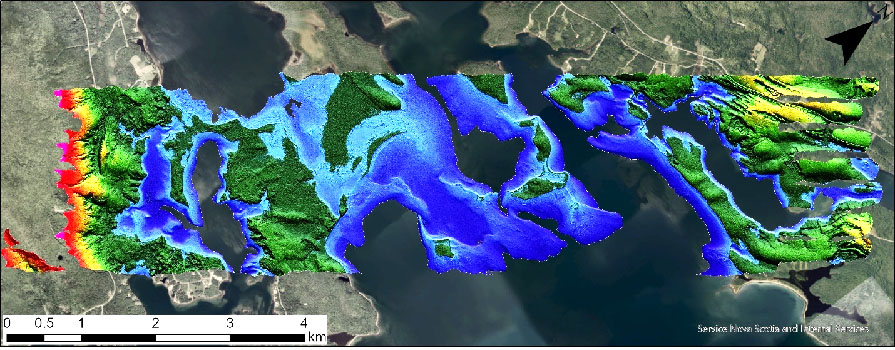
In partnership with archaeologists and geomatics specialists from Kwilmu'kw Maw-klusuaqn Negotiation Office (KMKNO), Applied Geomatics Research Group (AGRG) applied Etuaptmumk (Two-Eyed Seeing, the simultaneous application of local traditional and Western science) approach to investigate possible submerged Mi’kmaw archaeology sites beneath Pitu’poq (the Bras d’Or Lakes), Nova Scotia. The Mi’kmaw have lived in U'nama'kik (Cape Breton) for thousands of years, but there are very few archaeological sites that have been found. One reason for this is that they probably lived along the shores of the Bras D’Or Lakes in the summer and sea levels were much lower then, so any evidence of their encampments would have been submerged. The AGRG-KMKNO team used cutting-edge geomatics equipment, including AGRG’s airborne topo-bathymetric lidar sensor and data processing and visualization techniques, in combination with archaeological and traditional Mi’kmaw knowledge holders to model historical shorelines and identify areas of Mi’kmaw archaeological potential. The resources created from this project enhanced the KMK archaeologists’ identification of areas of archaeological potential and cultural sensitivity.
Challenge
KMKNO works to identify, map, document and preserve archeological sites which are relevant to both culture and treaty rights on behalf of the Maw-lukutijitk Saqmaq (Assembly of Nova Scotia Mi'kmaw Chiefs). Given the lack of sites in Cape Breton and the suspicion that many sites have been submerged by rising sea levels, a method to map the nearshore topography of the seabed was needed. The traditional marine archaeology method of using scuba diving to identify and map submerged sites is a slow, expensive and sometimes dangerous process. The challenge of this project was to develop a method to identify potential sites using remote sensing in the form of topo-bathymetric lidar and imagery, which is more cost effective and decreases risk of people being in the water. The data collected with lidar was validated with ground truthing techniques.
Outcomes
The outcome of this project was that multiple areas of high archaeological potential were identified using traditional Mi’kmaw and archaeological knowledge and geomatics techniques together. A ballast dump was identified from the lidar and confirmed with underwater video. While this probably represented an artifact from early European settlers and not the Mi’kmaw, it did prove the technique was useful. In addition to the ballast dump site, a piece of wood was found at the site of a predicted location of an ancient shoreline and was radiocarbon dated to 2334 years before present. The results of the project reestablished KMK archeologists’ determination that geomatics tools are key resources to garner insight into submerged landscapes, increase cost efficiency of research processes and make significant contributions to the management and protection of the non-renewable remains of Mi’kmaw heritage and culture. AGRG has applied for further funding to expand this work into a new three-year project.
“The opportunity to connect the near shore submerged topography with that which remains terrestrial, currently, in a synoptic view, supports interpretation and comprehension of long-term land use patterns and routines and how they may have been interrupted, historically, by colonial settlement and land use. This is both enlightening for the identification of Mi’kmaw archaeological heritage and in understanding the impacts of colonial land use on traditional Mi’kmaw ways of life.”
– Dr. Heather MacLeod-Leslie, Archaeology and Research Manager, Kwilmu’kw Maw-klusuaqn.
Partners
![]()